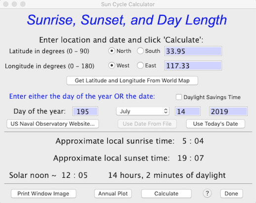
 This utility uses the well-known ‘Sunrise equation’ to compute the approximate times of sunrise and sunset from date (month, day, year) and location (degrees latitude and longitude). You need to select North or South latitude, and East or West longitude relative to the Prime Meridian. These coordinates can be entered directly, or you can use the 'Get Latitude and Longitude From World Map' button to select a location with a mouse click (this is not as accurate as directly entering exact coordinates, but should be close enough for most purposes, given the limitations discussed below).
NOTE: The program expects latitude and longitude in fractional degrees, not degrees and minutes. Thus 27° 30’ north should be entered as ’27.5’ (i.e., halfway between 27° N and 28° N).
Sun time estimates are approximate for several reasons:
- Sunrise and sunset times are based on local solar noon (i.e., when the sun is at its zenith (highest above the horizon) from the perspective of the observer’s position. Times based on solar noon are likely to be somewhat different from local time. As defined by people, time zones are arbitrary, and since they are roughly 15 ° of longitude wide and often do not run strictly north and south, sunrise and sunset times can vary by an hour or more with a single time zone. They can also be an hour different (sometimes more) from results of this calculator; these differences are typically greater a high latitudes.
- The calculator has no allowance for an observer's elevation above sea level (which makes rise times earlier and set times later, if the horizon is at sea level). It also has no allowance for local topography — for example, if the observer is in a deep valley, the visual horizon is elevated above the ‘real’ horizon, and rise times will be later and set times will be earlier than shown here.
- The precise times of sunrise and sunset are of concern to astronomers and the like, but for most purposes they are rather ‘fuzzy’ due to the angular diameter of the solar disc (about 32 minutes of arc or 0.53 degrees), atmospheric refraction, etc. Also, there are differing concepts of sunrise and sunset (e.g., the first or last glimpse of the solar disk above the horizon, vs. the sun's equator at the horizon, and so forth).
NOTE: The U.S. Naval Observatory hosts a web page (USNO Sun and Moon Data) that permits very accurate calculations of solar and lunar data. It incorporates ‘fixes’ for many of the issues described above, and — if you are connected to the internet — can be accessed with the ‘Naval Observatory Website’ button.
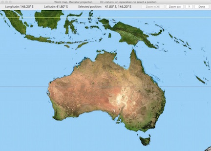
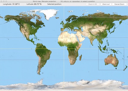 • The 'Get Latitude and Longitude From World Map' button opens a window with a world map (d'oh!) in Mercator projection. Move the cursor to the desired location and hit either the spacebar or return keys to select that position; as you move the cursor the latitude and longitude boxes at upper left update continuously. If you want to select a position on a higher-resolution 'regional' map, click the Zoom in X5 button, a rectangular cursor appears; move it until it encloses your area of interest and hit either the spacebar or return keys to enlarge that region. Then use the cursor and keys to select a position as described above.
 Location data are accurate only to 0.33 degree of longitude and 0.25 degree of latitude on the world map and 0.11 degrees of longitude and latitude on the regional maps, but that should be accurate enough for most sunrise-sunset calculations. Location data are accurate only to 0.33 degree of longitude and 0.25 degree of latitude on the world map and 0.11 degrees of longitude and latitude on the regional maps, but that should be accurate enough for most sunrise-sunset calculations.
As geographic references, the maps show the equator (yellow), the Prime or Greenwich Meridian (zero degrees of longitude), the Arctic and Antarctic Circles (~ 66.5 degrees N and S), and the Tropics of Cancer and Capricorn (~ 23.3 degrees N and S). Only a few of these will be visible on the enlarged regional maps.
Of course, if you want higher-resolution position data (and you are connected to the Internet), use Google Earth.
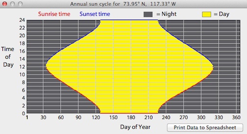
The 'Annual Plot' button will compute and display an entire year's day length cycle, based on latitude-longitude position. The 'Print Data to Spreadsheet' button makes a tab-delineated .xls spreadsheet containing the annual cycle (date, sunrise time, sunset time, and day length).
This example shows a Polar-region cycle, with complete darkness in winter and 24-hour sunlight in summer:
|
